
There were two tropical waves the National Hurricane Center had eyes on Saturday, one is a tropical wave over the Yucatan Peninsula of Mexico causing stormy weather in parts of Central America, while a low-pressure system in the Atlantic is being tracked and has a low chance of forming into an organized storm over the next week.
The tropical systems from Friday, which included invests or systems being investigated by the National Hurricane Center, that were causing rains across the gulf coast, were no longer on the NHC’s tracking maps Saturday morning.
On Saturday morning there were still parts of the Florida Panhandle and northern Florida that were under flood watch.
➤ Weather alerts via text: Sign up to get updates about current storms and weather events by location
The tropical waves the Hurricane Center’s tropical weather discussion from early 2 a.m Saturday mentioned these areas to watch:
-
A tropical wave over the Yucatan Peninsula, entering the Bay of Campeche
-
A tropical wave in the central Atlantic
-
A tropical wave in the tropical north Atlantic
Water temperatures in the Gulf of Mexico are extremely high, which helps tropical cyclones develop and strengthen.
Historically, about two-thirds of all Atlantic hurricane activity occurs between Aug. 20 and Oct. 10, said Philip Klotzbach, meteorologist at Colorado State University specializing in Atlantic basin seasonal hurricane forecasts.
Expect tropical activity to ramp up
Wind shear, which has helped prevent tropical waves from organizing, is expected to lessen by the middle of September.
Along with the long-expected transition to La Niña and reduction in the amount of Saharan dust, forecasters are expecting tropical activity to increase this month.
The next named storm of the season will be Francine.
Here’s the latest update from the NHC as of 2 a.m., Sept. 7:
What else is out there and how likely are they to strengthen?
A tropical wave over the Yucatan Peninsula of Mexico is producing disorganized showers and thunderstorms over Guatemala, southeastern Mexico, and the adjacent waters of the southwestern Gulf of Mexico. The wave is expected to move over the Bay of Campeche later Saturday.
-
Formation chance through 48 hours: medium, 40 percent.
-
Formation chance through 7 days: medium, 60 percent.
A trough of low pressure over the eastern and central tropical Atlantic is producing a showers andthunderstorms. A more well-defined area of low pressure may form within this region during the next few days.
-
Formation chance through 48 hours: low, near zero percent.
-
Formation chance through 7 days: low, 30 percent.
What is an invest?
Short for investigation, the National Hurricane Center uses the term invest for areas of low pressure it is monitoring for potential development into a tropical depression or storm.
Northwestern Caribbean Sea and Southwestern Gulf of Mexico: A tropical wave located near the coast of Belize and the Yucatan Peninsula of Mexico continues to produce disorganized showers and thunderstorms.
What do the colored areas on the NOAA map mean?
The hatched areas on a tropical outlook map indicate “areas where a tropical cyclone — which could be a tropical depression, tropical storm or hurricane — could develop,” said National Hurricane Center Deputy Director Jamie Rhome.
The colors make it visibly clear how likely a system could develop with yellow being low, orange medium and red high.
The National Hurricane Center generally doesn’t issue tropical advisories until a there is a named storm, but there is an exception.
“If a system is near land and there is potential for development, the National Hurricane Center won’t wait before it issues advisories, even if the system hasn’t become an actual storm. This gives residents time to prepare,” Rhome said.
Who is likely to be impacted?
It’s too early at this time to determine if there will be any impact to Florida or the U.S. from any of the other tropical waves out there.
Forecasters urge all residents to continue monitoring the tropics and to always be prepared. That advice is particularly important for what is expected to be a very active hurricane season.
Florida tax holiday: Time ends today to save on hurricane supplies
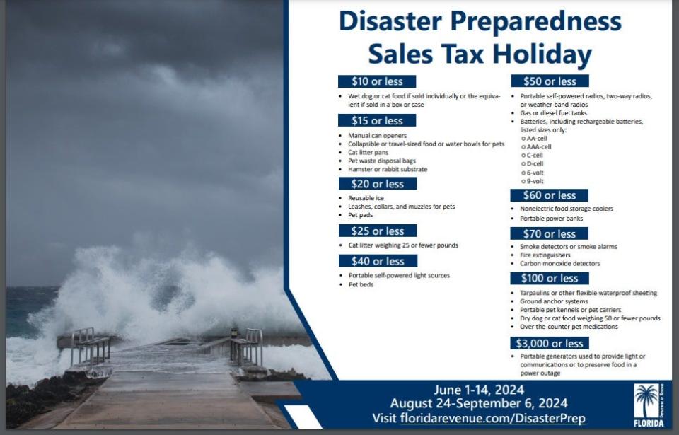
Florida’s final disaster preparedness tax holiday is winding to a close, but you still have a two more days to save money on any needed hurricane supplies for you or your pet.
The tax holiday ends Sept. 6, just days before the peak of hurricane season arrives. And don’t forget the busiest period historically lasts until mid-October. This year, though, tropical threats could extend through November and possibly into December this year, due in part to extremely warm water temperatures, Porter said.
Here’s what you can buy tax free:
-
A portable generator used to provide light or communications or preserve food in the event of a power outage with a sales price of $3,000 or less.
-
A tarpaulin or other flexible waterproof sheeting with a sales price of $100 or less.
-
An item normally sold as, or generally advertised as, a ground anchor system or tie-down kitwith a sales price of $100 or less.
-
A smoke detector or smoke alarm with a sales price of $70 or less.
-
A fire extinguisher with a sales price of $70 or less.
-
A carbon monoxide detector with a sales price of $70 or less.
-
A nonelectric food storage cooler with a sales price of $60 or less.
-
A portable power bank with a sales price of $60 or less.
-
A gas or diesel fuel tank with a sales price of $50 or less.
-
A portable self-powered radio, two-way radio, or weather-band radio with a sales price of$50 or less.
-
A package of AA-cell, AAA-cell, C-cell, D-cell, 6-volt, or 9-volt batteries, excluding automobileand boat batteries, with a sales price of $50 or less.
-
A portable self-powered light source (powered by battery, solar, hand-crank, or gas) with asales price of $40 or less.
-
Flashlights
-
Lanterns
-
Candles
-
-
Reusable ice (ice packs) with a sales price of $20 or less.
Do you need a generator? With active hurricane season ahead, do you need a generator in Florida? Here’s how to decide
Also included in the tax holiday are any supplies necessary for the evacuation of household pets. Necessary supplies means the noncommercial purchase of:
-
Bags of dry cat or dog food weighing 50 or fewer pounds and with a sales price of $100 or less per bag.
-
Portable kennels or pet carriers with a sales price of $100 or less per item.
-
Over-the-counter pet medications with a sales price of $100 or less.
-
Pet beds with a sales price of $40 or less per item.
-
Cat litter weighing 25 or fewer pounds and with a sales price of $25 or less per item.
-
Leashes, collars, and muzzles with a sales price of $20 or less per item.
-
Pet pads with a sales price of $20 or less per box or package.
-
Manual can openers with a sales price of $15 or less per item.
-
Collapsible or travel-sized food bowls or water bowls with a sales price of $15 or less per item.
-
Cat litter pans with a sales price of $15 or less per item.
-
Pet waste disposal bags with a sales price of $15 or less per package.
-
Hamster or rabbit substrate with a sales price of $15 or less per package.
-
Cans or pouches of wet dog food or cat food with a sales price of $10 or less per can or pouch or the equivalent if sold in a box or case.
Weather watches and warnings issued in Florida
When is the Atlantic hurricane season?
The Atlantic hurricane season runs from June 1 through Nov. 30.
The Atlantic basin includes the northern Atlantic Ocean, Caribbean Sea and Gulf of Mexico.
Stay informed. Get weather alerts via text
When is the peak of hurricane season?
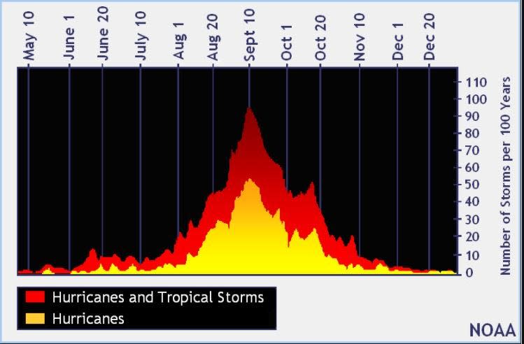
The peak of the season is Sept. 10, with the most activity happening between mid-August and mid-October, according to the Hurricane Center.
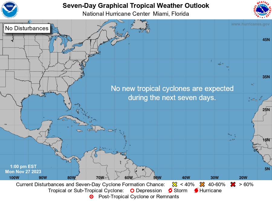
National Hurricane Center map: What are forecasters watching now?
Systems currently being monitored by the National Hurricane Center include:
Interactive map: Hurricanes, tropical storms that have passed near your city
Excessive rainfall forecast
What’s next?
We will continue to update our tropical weather coverage daily. Download your local site’s app to ensure you’re always connected to the news. And look for our special subscription offers here.
This article originally appeared on The Daytona Beach News-Journal: Hurricane Center tracking 2 tropical waves in Gulf, Atlantic

Amanda Smith is a dedicated U.S. correspondent with a passion for uncovering the stories that shape the nation. With a background in political science, she provides in-depth analysis and insightful commentary on domestic affairs, ensuring readers are well-informed about the latest developments across the United States.


