Severe weather outbreak expected from Plains into Midwest this weekend
The storms firing up on Thursday afternoon are just the beginning of tornado risks over the coming days.
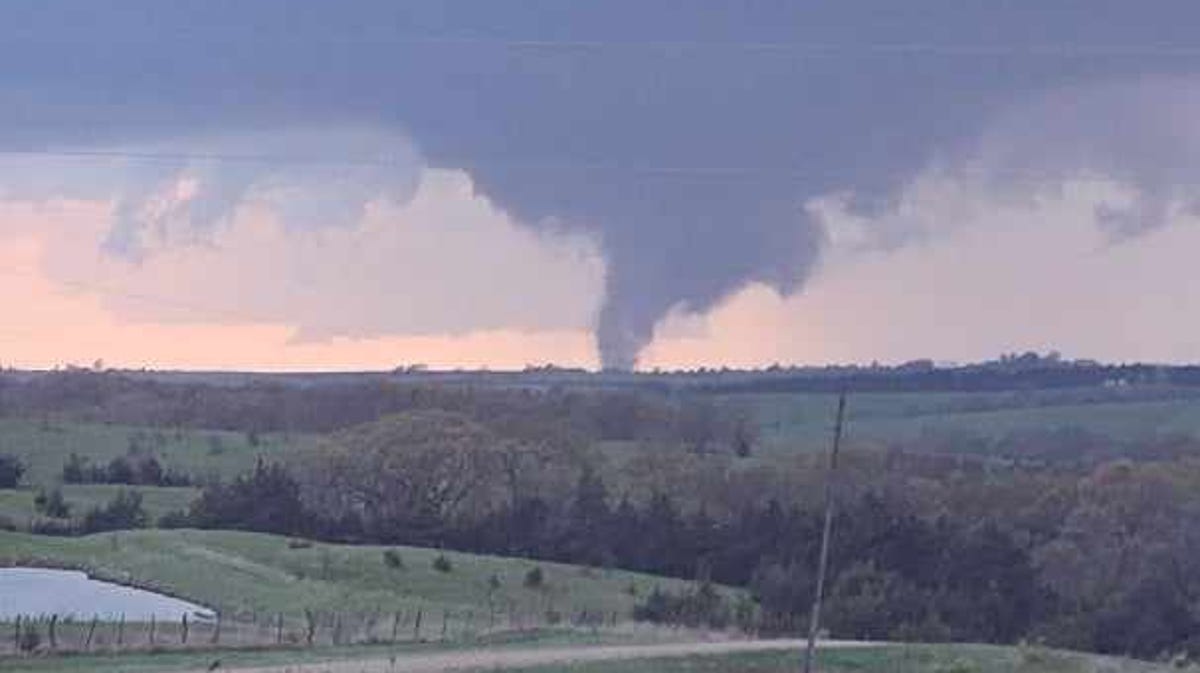
Multiple ”large and extremely dangerous” tornadoes touched down across western and central Iowa Friday night, including near Pleasant Hill on the eastern side of the city, according to the National Weather Service.
The town of Minden suffered significant damage, according to state officials. But no fatalities had been reported so far Friday night.
The storms were part of a strong system that swept eastward across the state, bringing heavy rain and large hail as tornado watches and warnings were issued county by county.
Showers and storms are likely again Saturday, the National Weather Service says, particularly by mid- to late afternoon and into the evening. Some storms may be strong to severe, capable of producing large hail and damaging winds — and a few tornadoes cannot be ruled out, particularly in southern and into central Iowa.
Those with outdoor interests are cautioned to have a sheltering plan ready and have multiple ways to receive warning updates, the NWS says.
11:45 a.m.: Tornado destroys homes in Pleasant Hill
A tornado swept through Pleasant Hill on Friday night, April 26, damaging 18 homes and injuring one person, according to the city’s fire chief.
Pleasant Hill Fire Department Chief Jamie Xayavong told reporters at an 11 a.m. news conference Saturday that the injury was not life-threatening, though the damaged homes were no longer inhabitable.
Xayavong did not know how strong the tornado was, though it left several other homes with moderate or minor damage. She indicated that more damage reports could come in as recovery continues. She said none of the misplaced residents needed emergency shelter.
11:15 a.m.: Reports of Friday night tornado in Ringgold County in southwest Iowa
A tornado swept through the small southwestern Iowa towns of Tingley and Redding on Friday, April 26, according to Melissa Stark with Ringgold County Emergency Management. Officials believe the tornado developed around 8 p.m. Friday, traveling the entire length of the county and leaving significant damage in its wake.
Stark said residents had little warning, noting that the sirens weren’t triggered until the tornado had developed.
No injuries have been reported.
11 a.m.: Creston recovering from storm damage
U.S. Rep. Zach Nunn said he was headed to Creston to meet with the Union County Sheriff to tour the community and offer his support.
The storm damaged portions of the Homestead Assisted Living’s roof in the northwest part of town. Several windows and the main entrance also suffered damage. A private home in Creston was also damaged in the storm.
“Iowa just emerged from a horrible event that occurred many of our communities last night. In fact, we’re headed down to Union County next to help take care of Creston and the communities that were impacted by horrible storms and tornadoes that ravaged the state of Iowa,” he said at a campaign event Saturday morning. “Our prayers not only are with Minden but those communities in Nebraska where we’ve flown flight operations out of. They’re just decimated. And so this morning as we think about what we need to do, it should always be about how do we help those communities in need.”
U.S. Highway 34 between Creston and Afton was closed Friday night due because debris blocked the road, according to Iowa 511.
10:45 a.m.: Tiny Minden, Iowa, riddled with debris after tornado smashes through town Friday
Many houses, cars, and trees in Minden have been destroyed after a tornado devastated the southwestern Iowa town of roughly 600 people Friday evening, April 26.
Access to the town was shut off Saturday because of the destruction.
Drivers trying to pass through Minden Saturday morning were being redirected as workers tried to clean up wholesale debris left behind.
For Austin Ehlers, a firefighter in Persia, a city just about 15 minutes away from Minden, the tornado demolished his grandfather’s home.
“He lives just outside of Minden, right in the path where the tornado took,” Ehlers said. “After we cleared everything in Persia, we hoped in the trucks and went to Minden and helped. I found out my grandpa’s house was completely gone, and he’s basically lost everything.”
More: Tiny Minden, Iowa, riddled with debris after tornado smashes through town Friday
10:30 a.m.: Are more tornadoes headed for Iowa? The National Weather Service forecast
Is another round of tornadoes heading to Iowa?
One day after bands of tornadoes swept through western and central Iowa Friday, the National Weather Service is warning of the possibility of strong to severe storms Saturday afternoon through the evening.
“All severe weather hazards are possible, but hail and damaging winds are the primary threats,” the National Weather Service in Des Moines reported.
More: Could more tornadoes be headed to Iowa? The National Weather Service forecast
Showers and storms continue into Sunday, along with the potential for more strong to severe storms Sunday afternoon and evening, the NWS said.
“The extent of the threat and most likely hazards remains uncertain at this time,” it posted.
The NWS warned that spotter activation may be needed later Saturday and Sunday.
Chances for showers and storms return Tuesday into Tuesday night, and again late in the week. The severe weather threat is uncertain and will be evaluated in the coming days.
With the potential for more severe weather, it’s good to be prepared. Make sure you have a plan in place. Here are five things you should know to be prepared for a weather emergency.
The National Weather Service in Des Moines posted early Saturday morning that preliminary reports indicate at least 10 tornadoes struck central Iowa in the April 26 storm front, based on initial damage information.
Another band of tornadoes swept across Nebraska and western Iowa.
Damage to trees and homes were reported from Crawford to Union to Ringgold up to Polk and Jasper counties, the office said. At least one injury was reported.
In Nebraska and western Iowa, a swath of damage stretched from just northeast of Lincoln, Nebraska, through the Waterloo and Elkhorn areas, and all the way to near Soldier, Iowa, in eastern Monona county. NWS Omaha issued 42 tornado warnings during the outbreak, it reported.
Two NWS teams from the Des Moines office will survey damaged areas on Saturday. The office will begin to post survey results Saturday, but it will likely take days to rate the severity and path of all the touchdowns.
Friday’s system ushered strong storms across the state, leaving widespread debris and devastation in their wake.
The small town of Minden in northcentral Pottawattamie County appears to have suffered some of the most significant damage, according to state officials and storm chasers, who posted photos and videos of leveled houses and businesses.
As of about 11 p.m. Friday night, no fatalities had been reported in the town, which is 90 minutes west of Des Moines on I-80.
In response to the severe weather, Gov. Kim Reynolds issued a disaster proclamation for Pottawattamie County. The proclamation initiates the Iowa Individual Assistance Grant Program and the Disaster Case Advocacy Program.
Saturday could see more scattered thunderstorms in the afternoon, a few of which could be serve and bring heavy rain. Those storms may continue through Sunday morning.
Staying weather aware will be important for the rest of the weekend. Look out for wireless emergency alerts on your smartphone or stay up to date on forecasts at weather.gov/desmoines.
A few other tips for staying safe:
- Get in: If you are outside, get inside. If you’re already inside, get as far into the middle of the building as possible.
- Get down: Get underground if possible. If you can’t, go to the lowest floor possible.
- Cover up: Flying and falling debris are a storm’s number one danger. Use pillows, blankets, coats, helmets to cover up and protect your head and body from flying debris.
11 p.m.: Severe thunderstorm ‘capable of producing a tornado’ spotted over Knapp Center and Drake Stadium
A severe thunderstorm ‘capable of producing a tornado’ was seen over Drake Stadium and the Knapp Center, according to the National Weather Service. The system was moving northeast at 45 mph.
A tornado warning was issued for central Polk County until 11:45 p.m.
“Flying debris will be dangerous to those caught without shelter,” said the NWS. “Mobile homes will be damaged or destroyed. Damage to roofs, windows and vehicles will occur.”
Drake University is hosting the Drake Relays. No information on delays or cancelations for Saturday’s events had been announced by 11:15 p.m. Friday.,
After an evening of strong storms that brought multiple “large and dangerous” tornadoes, heavy rain and sizable hail, most of the system has dissipated.
The last tornado warning issued in the area was in northeast Jasper County and expired at 10:30 p.m.
Metro counties Polk, Warren, Madison and Jasper — as well as many southcentral counties — are still under a watch until midnight.
Full list of counties remaining under a tornado watch until midnight:
- Adams
- Appanoose
- Clarke
- Decatur
- Jasper
- Lucas
- Madison
- Marion
- Monroe
- Polk
- Ringgold
- Taylor
- Union
- Warren
- Wayne
Several cross-streets are completely blocked by emergency crews and tree debris south of the Pleasant Hill Hy-Vee. Lots of traffic seem to be trying to leave the surrounding neighborhoods, which are without power.
There are about 15,000 MidAmerican Energy customers without power, according to the utility.
At least 11,843 east-side residents were without power, according to MidAmerican.
U.S. Highway 34 between Creston and Afton closed Friday night due to debris blocking the road, according to Iowa 511.
A command center for ambulances and family reunification was set up at Walmart on Laurel St., according to the Creston Police Department. No fatalities or injuries have been confirmed as of about 9:30 p.m. in Creston, according to the police department.
Zach Bryan’s Quittin’ Time Tour will go on as scheduled, according to the Iowa Events Center.
“We are following our established severe weather protocols while we are in a tornado warning,” said Adam Flack, director of marketing for the arena. “The show will go on and we have closed the concourse until the warnings expire. Everyone is encouraged to stay inside the seating bowl away from entrances and glass.”
The National Weather Service has confirmed a “large and extremely dangerous tornado” over Pleasant Hill. It is moving northeast at about 35 mph.
Those in the area are in “a life-threatening situation,” NWS said. “Flying debris may be deadly to those caught without shelter. Mobile homes will be destroyed. Considerable damage to homes, businesses, and vehicles is likely and complete destruction is possible.”
The tornado warning issued for Southeastern Polk and Western Jasper Counties is extended until 9:30 p.m.
KCCI reported that the Pleasant Hill tornado was “lofting” debris into the air.
The system is “one of the most intense rotational signatures we’ve seen today,” said meteorologist Jason Sydejko.
At Southeast Polk Jr. High School, a production of “Annie Jr.” was stopped and the audience was ushered to shelter in the hallway.
The National Weather Service in Des Moines has issued tornado warnings until 9:30 p.m. for the following counties:
- Southeastern Union County
- Northeastern Ringgold County
- Northeastern/west central Clarke County
- Northwestern Lucas County
- Northwestern/west central Marion County
- Northeastern/southeastern Warren County
- Southeastern Polk County
- Western Jasper County
Multiple tornadic super cells are making their way into the metro, according to KCCI.
Sirens have been heard across the metro area.
Urbandale and Clive residents should be in their safe spaces. Metro residents should also get to basements or below ground level.
- Get in: If you are outside, get inside. If you’re already inside, get as far into the middle of the building as possible.
- Get down: Get underground if possible. If you can’t, go to the lowest floor possible.
- Cover up: Flying and falling debris are a storm’s number one danger. Use pillows, blankets, coats, helmets to cover up and protect your head and body from flying debris.
- Look out for wireless emergency alerts on your smartphone or stay up to date on forecasts at weather.gov/desmoines.
At 8:23 p.m., a confirmed tornado was located near Cumming, or near West Des Moines, moving northeast at 25 mph, according to the National Weather Service.
In response to the severe weather Friday night, Gov. Kim Reynolds issued a disaster proclamation for Pottawattamie County. The proclamation initiates the Iowa Individual Assistance Grant Program and the Disaster Case Advocacy Program.
Minden, which was hit hard by a tornado earlier in the evening, sits in northern section of the county.
From a news release:
The Iowa Individual Assistance Grant Program provides grants of up to $5,000 for households with incomes up to 200 percent of the federal poverty level. Grants are available for home or car repairs, replacement of clothing or food, and temporary housing expenses. Original receipts are required for those seeking reimbursement for actual expenses related to storm recovery. The grant application and instructions are available on the Iowa Department of Homeland Security and Emergency Management website at homelandsecurity.iowa.gov/assistance. Potential applicants have 45 days from the date of the proclamation to submit a claim.
The Disaster Case Advocacy Program addresses serious needs related to disaster-related hardship, injury, or adverse conditions. Disaster case advocates work with clients to create a disaster recovery plan and provide guidance, advice, and referrals to obtain a service or resource. There are no income eligibility requirements for this program; it closes 180 days from the date of the governor’s proclamation. For information on the Disaster Case Advocacy Program, contact your local community action association or visit iowacommunityaction.org.
The National Weather Service in Des Moines has issued a tornado warning for Polk, Madison, Dallas and Warren counties until 8:45 p.m.
The tornado warning includes:
Des Moines, West Des Moines, Ankeny, Urbandale, Johnston, Clive, Altoona, Waukee, Norwalk, Pleasant Hill, Grimes, Windsor Heights, Saylorville, Granger, Jordan Creek Town Center, Merle Hay Mall, Iowa Events Center, Iowa State Fairgrounds, Des Moines Int`l Airport, and Principal Park.
The Tornado watch issued by the National Weather Service has been extended to midnight in 10 counties, including Polk, Jasper, Boone and Story counties. Further South, counties including Appanoose, Lucas, Marion, Monroe, Warren and Wayne are under the same watch.
The metro as well as larger population centers like Ames, Indianola, Newtown, Knoxville and Pella are now covered by the watch.
Possible threats connected to this storm system could include “a few tornados” with “a couple intense tornados possible,” according to the National Weather Service. Damaging winds could gust to about 70 mph and scattered large hail, including pieces possibly measuring 2.5 inches in diameter, are also possible.
Storm chasers have posted video and photos of what looks to be catastrophic damage in Minden, Iowa, located about 90 minutes west of Des Moines on I-80.
The National Weather Service in Des Moines has issued a tornado warning for southwestern Madison, central Union, western Clarke and southeastern Adair counties until 8:30 p.m.
At 7:43 p.m., NWS confirmed a tornado located over Creston Municipal Airport moving northeast at 35 mph.
At 7:47 p.m., NWS confirmed a tornado located over Mt Ayr Municipal Airport moving northeast at 35 mph.
The National Weather Service in Des Moines confirmed a tornado located near Afton moving northeast at 30 mph.
At 7:34 p.m., another tornado was reported near Redding moving northeast at 40 mph.
The National Weather Service in Des Moines has issued a tornado warning for Madison, Union, Adair and Ringgold counties until 8 p.m.
At 7:16 p.m., a severe thunderstorm capable of producing a tornado was located 5 miles northeast of Green Valley Lake State Park moving northeast at 40 mph.
At 7:21 p.m., a severe thunderstorm capable of producing a tornado was located over Irena moving northeast at 45 mph.
The National Weather Service in Des Moines confirmed a tornado located over Manilla moving northeast at 45 mph.
At 7:05 p.m., NWS confirmed a tornado located over Creston moving northeast at 40 mph.
At 7:07 p.m., NWS confirmed a new tornado located 5 miles south of Vail moving northeast 40 mph.
The NWS reports that the tornados are on the ground and residents should take cover.
The National Weather Service in Des Moines has issued a tornado warning for Union, Adams and Adair counties until 7:45 p.m. Friday.
At 6:54 p.m., the NWS confirmed a severe thunderstorm capable of producing a tornado near Kent moving northeast at 30 mph.
The National Weather Service in Des Moines has issued a tornado warning for northeastern Crawford County in west central Iowa until 7:30 p.m.
At 6:43 p.m., the NWS confirmed a “large and extremely dangerous” tornado located 5 miles southwest of Vail moving north at 30 mph.
The NWS has labeled the tornado as life-threatening and urges residents to take cover.
The National Weather Service in Des Moines confirmed a “large and extremely dangerous” tornado was located near Irwin moving northeast at 30 mph.
The NWS has labeled this a “particularly dangerous situation” and urges residents to take cover.
The National Weather Service in Des Moines has issued a tornado warning from southeastern Adams County and Taylor County until 7 p.m. Friday.
At 6:20 p.m., a severe thunderstorm capable of producing a tornado was located 5 miles east of Braddyville moving northeast at 40 mph.
At 6:28 p.m., the thunderstorm was located near Corning Municipal Airport moving northeast at 55 mph.
The storm could produce a tornado as well as quarter-size hail.
Spotters confirmed a tornado around 5:15 p.m. about 9 miles east of Council Bluffs, The National Weather Service reported. The tornado was moving northeast at 45 mph.
A tornado touched down in another area about 7 miles southwest of Treynor, moving in the same direction.
NWS radars also confirmed a different tornado 7 miles northwest of Neola around 5:20 p.m.
A tornado watch has been issued for parts of central Iowa until 9 p.m. Friday.
The watch picks up on the edge of an earlier tornado watch in western Iowa and extends up to the Des Moines metro area. Dallas County is included in the watch, but Polk, Story and Warren counties are not at this time.
Severe weather including a few tornadoes, large hail and strong wind gusts are possible, according to the National Weather Service in Des Moines. Isolated heavy rainfall may also occur.
A tornado watch has been issued by the National Weather Service for parts of western Iowa until 7 p.m. Friday.
Counties in the watch are at risk of seeing tornadoes, apple-sized hail and wind gusts up to 70 mph.
This is the first wave in a weekend of storms expected in Iowa. Most of the state has the potential to see severe storms, tornadoes and heavy rainfall all weekend. Storms are expected to move toward central Iowa in the evening hours Friday.
More: What’s the difference between a severe weather watch and a warning?
Here’s a look at the National Weather Service’s Des Moines radar loop:
Staying weather aware will be important. Look out for wireless emergency alerts on your smartphone or stay up to date on forecasts at weather.gov/desmoines.
NWS has some more tips for severe weather:
- Get in: If you are outside, get inside. If you’re already inside, get as far into the middle of the building as possible.
- Get down: Get underground if possible. If you can’t, go to the lowest floor possible.
- Cover up: Flying and falling debris are a storm’s number one danger. Use pillows, blankets, coats, helmets to cover up and protect your head and body from flying debris.

Sarah Wilson is your guide to the latest trends, viral sensations, and internet phenomena. With a finger on the pulse of digital culture, she explores what’s trending across social media and pop culture, keeping readers in the know about the latest online sensations.