New storm threatens with blizzard, flooding and winds
Yet another significant weather system will pummel parts of the central and eastern United States into the weekend, including blizzard conditions, intense winds and severe weather.
Iowans have been patiently waiting for snow, and snow we got — lots of it. After setting a record on Jan. 9, another winter storm is heading our way. Most of Iowa will feel the effects.
A blizzard warning will be in effect from 10 a.m. Friday until 6 a.m. Saturday in northwest and central Iowa, according to the National Weather Service. In eastern Iowa, a blizzard warning starts at 5 p.m. Friday and extends until noon on Saturday.
Wind gusts as high as 40 mph are expected Friday afternoon and night, which will blow around snow and reduce visibility. Travel is expected to be very difficult, and is recommended to be avoided if possible.
Blizzard warnings are issued for frequent gusts greater than or equal to 35 mph accompanied by falling and/or blowing snow, according to NWS. Blizzards frequently reduce visibility to less than 1/4 mile for three hours or more.
A blizzard warning means severe winter weather conditions are expected — as in the case right now — or already occurring. Falling and blowing snow with strong winds and poor visibilities are likely, leading to whiteout conditions making travel extremely difficult.
NWS recommends Iowans not travel during a blizzard warning. If you must travel, have a winter survival kit with you. If you get stranded, stay with your vehicle and wait for help to arrive.
Winter storm warnings are issued for a significant winter weather event that includes snow, ice, sleet or blowing snow or a combination of these hazards. Travel is often difficult or impossible when winter storm warnings are in effect. If a winter storm warning is in effect, you should consider delaying your travel plans until conditions improve.
Des Moines Public Schools announced Thursday afternoon that classes will be canceled for Friday due to the forecast. All activities are canceled, and Metro Kids Care is closed. All offices will be closed.
Other large metro school districts including Johnston, Southeast Polk and Waukee have also canceled Friday classes. Urbandale had a previously scheduled professional work day without classes on Friday. Staff will work remote and child care will not be available.
When is snow supposed to start in Iowa and what does the forecast show?
Snowfall will begin over western Iowa late Thursday afternoon, according to National Weather Service’s Des Moines office.
On Thursday, there’s a 70% chance of snow in Ames at 6 p.m., an 85% chance in Carroll at 6 p.m. and a 75% chance in Des Moines at 6 p.m.
Heaviest snowfall rates will be early Friday morning through mid-day. There is also a chance of freezing rain in the morning on Friday.
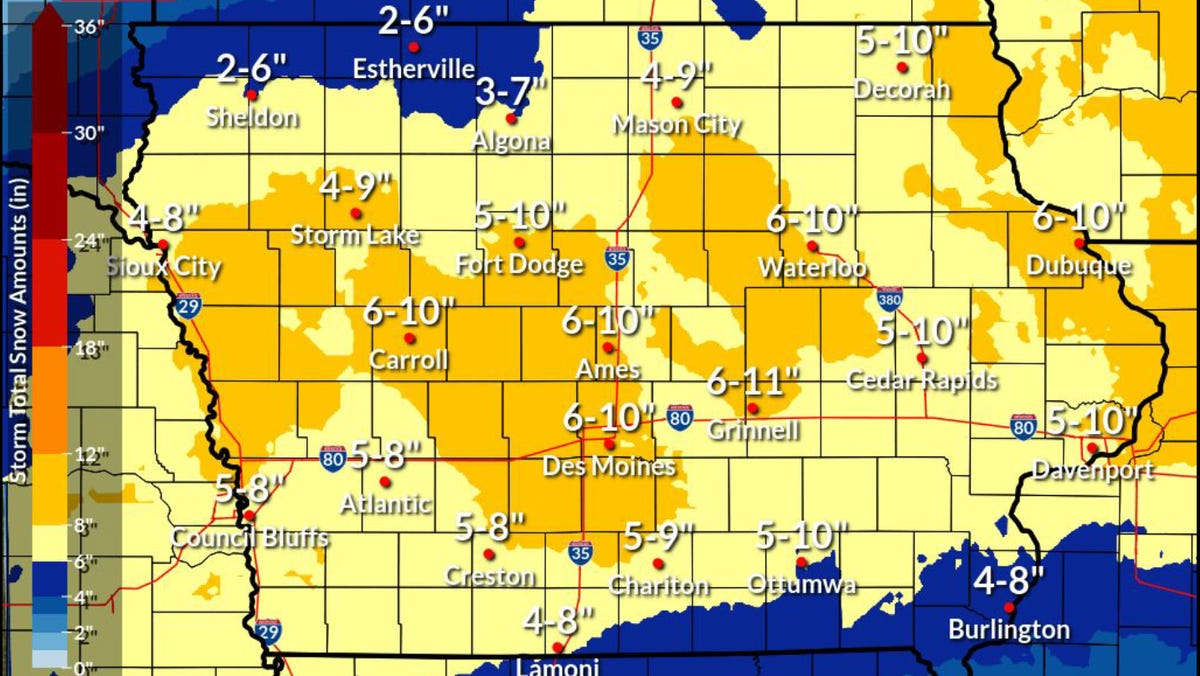
How much snow will Iowa get?
The NWS says significant snow will come to most of the state. Snow could fall at as much as an inch an hour during the overnight hours on Thursday. Wind gusts of 35-45 miles per hour will create “near-blizzard” conditions and could create whiteout conditions.
Most of the state is looking at 5-10 inches of snowfall with the heaviest areas landing around Des Moines, Ames and Carroll. Heavier pockets are also possible around Waterloo and Dubuque.
Maybe! The official total at the Des Moines International Airport from the first snowstorm this week was 11.2 inches.
The current 5-day record in Des Moines is 22.7 inches (Dec. 28, 1941 – Jan. 1, 1942), according to a post from the NWS. If Des Moines gets 10 more inches, we won’t break that record. But, we could break the second-place record of 20.2 inches (March 14-18, 1923).
Winter weather will likely delay metro bus services Thursday evening through Saturday, and especially on Friday, according to a news release from the Des Moines Area Regional Transit Authority.
Those using DART Paratransit, On Demand, or Flex Connect services, should prepare for ride delays depending on the amount of snowfall and blizzard-like conditions, DART officials said. DART officials will not be able to pick up or drop off passengers in parking lots that have not been plowed.
Here are the possible service delays depending on the amount of snowfall, according to DART:
- 2 to 3 inches of snow: Pick-up times could be delayed by 30 to 60 minutes.
- 3 to 5 inches: Pick-up times could be delayed by 60 minutes or more.
- 5 to 8 inches: Pick-up times could be significantly delayed by more than 60 minutes. Customers with non-critical trips are asked to reschedule trips for another day.
Buses running more than 20 minutes late will be posted on DART’s website.
How cold will temperatures get in Iowa?
The winter storm will also be accompanied by bitter cold temperatures.
Highs across the state will be in the teens to mid-20s on Thursday and will drop into the single digits by Saturday.
Wind gusts will be in the 30-40 miles per hour range through the weekend. Wind chills will reach their lowest levels on Sunday with ranges in the -20 to -45 range across the state.
Parking restrictions automatically kick in for most cities in central Iowa once 2 inches of snow have fallen. Often cities will activate restrictions in advance of major snowstorms.
More: Des Moines snow parking rules: Where and when it’s safe, and where you could be ticketed
Here are the metro cities that have announced restrictions ahead of this winter storm:
- Altoona: The snow removal parking ban is in effect in Altoona beginning at 5 p.m. on Thursday, Jan. 11 through 5 p.m. on Saturday, Jan. 13 or until all city roadways are cleared.
- Ames: A snow ban will start at 10 p.m. Thursday for all snow routes marked by red and white signs. The ban continues until roads are completely cleared curb to curb, likely until Saturday morning.
- Ankeny: Parking is not allowed on all public streets, alleys and on-street parking within the city from 9 p.m. Thursday to 9 p.m. Saturday. Vehicles parked on the street during the snow ordinance will be ticketed $40 and may be towed. Parking is also prohibited in The District at Prairie Trail and Uptown Business District from 2-6 a.m.
- Clive: Residents are asked to move their parked vehicles from city streets.
- Des Moines: Snow ordinances are lifted in all residential districts of Des Moines except for in odd/even neighborhoods: Drake, Carpenter, River Bend and Sherman Hill. Signage will direct drivers on which side of the street to park based on the day of the week, between 7 a.m. and 7 p.m.
- Indianola: Prohibits parking on any public street or alley, this ordinance remains in effect for 48 hours after the snow has stopped falling or until the streets are clear.
- Johnston: The City of Johnston has declared a snow ordinance effective Thursday at 6 p.m. until Friday, Jan. 12 at 5p.m. During this time, no parking is allowed on city streets. If residents park on a city street, they could receive a ticket.
- Waukee: A parking ban will start at 7 p.m. Thursday and continue until 5 p.m. Saturday. Cars left on city streets are subject to $25 fines and/or towing.
- West Des Moines: An emergency parking ban for snow removal goes into effect Thursday at 10 p.m. and lasts until 5 p.m. on Friday, Jan. 12. The parking ban applies to all streets in West Des Moines, and cars are subject to a $50 fine and/or towing.
Victoria Reyna-Rodriguez is a general assignment reporter for the Register. Reach her at [email protected] or follow her on Twitter @VictoriaReynaR.

Amanda Smith is a dedicated U.S. correspondent with a passion for uncovering the stories that shape the nation. With a background in political science, she provides in-depth analysis and insightful commentary on domestic affairs, ensuring readers are well-informed about the latest developments across the United States.


