What is the forecast for Friday?
There is a tornado watch in effect for Le Flore and Pushmataha County in Oklahoma until 4 a.m. Friday.
There were some noisy storms in eastern Oklahoma Thursday night that brought a bit of hail to a few places. These were forming out ahead of the Arctic cold front that arrives overnight.
Those storm systems brought a Severe Thunderstorm Warning to the Tahlequah area until 11:15 p.m. It quickly moved into the Arkansas area.
While some snow chances will quickly return Friday morning, another surge of very cold air arrives Saturday evening bringing some snow chances Sunday. Cold weather preparations should be completed today before the initial surge of cold air arrives overnight and early Friday morning.
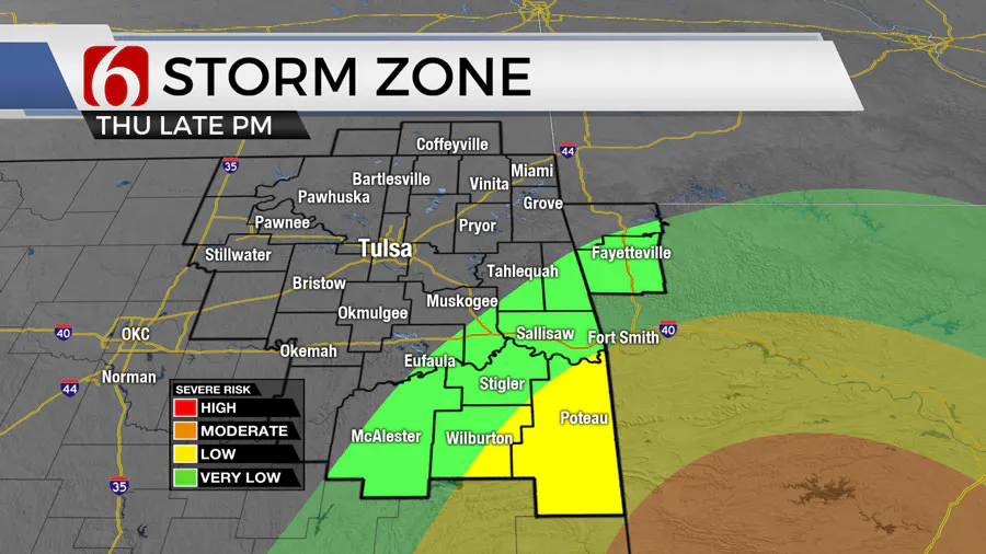
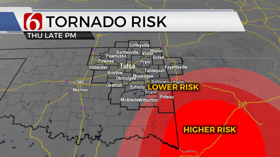
A strong cold front will move across the area later tonight supporting a chance for a few strong to severe storms across extreme southeastern OK into the ArkLaTex between 9pm tonight and 2am Friday morning. Some of these could be significantly severe, including the potential for a tornado. As the front rapidly moves eastward, colder air quickly arrives. Some moisture remaining on the back side of the upper-level trough will attempt to transition from rain to snow early Friday morning across part of eastern OK into northwestern Arkansas between 4am to 9am.
Related Story: Temporary Warming Shelters Needed Ahead Of Below Freezing Weather
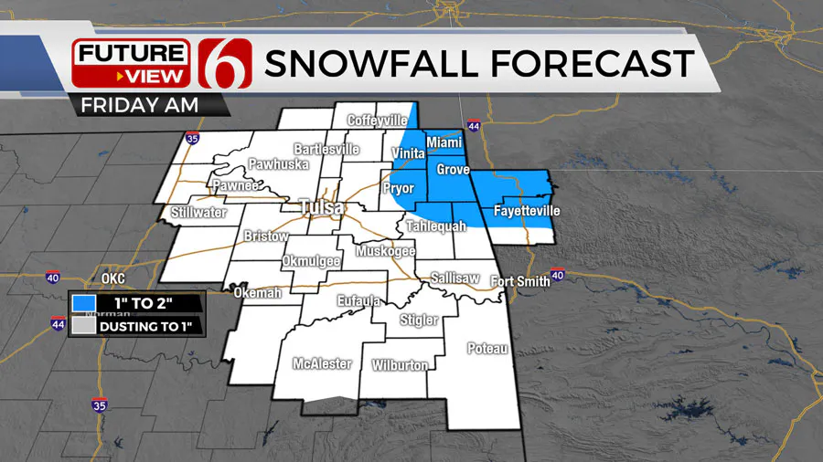
How much snow could Oklahoma get?
Recent data suggest amounts between a dusting to near 1 inch will be possible near Tulsa, with higher amounts along the far Eastern OK and Western Arkansas state line region. Temps will drop below freezing as this wintry weather probability arrives. The timing could again coincide with the part of the Friday morning commute. Some travel issues will be possible with this small window for snow before the wave quickly exits the area.
The leading edge of cold air will move across southern OK but may stall along the Red River Valley Friday evening, and possibly nudge northward a few hours Saturday. This will create some differences in temps from the north to south both Friday and Saturday. The current forecast would keep the northern half of the area near and below freezing both Friday and Saturday, while some locations across southeastern OK could see a broad range of afternoon highs ranging from the lower 30s along the I-40 corridor into the lower 50s along the Red River Valley.
Saturday afternoon or evening, a second and more significant surge of cold air arrives and should bring the deeper air mass southward across the entire state. This will bring bitterly cold temps Sunday morning with lows in the single digits to lower teens with afternoon highs in the teens. Northeast winds at 15 to 25 mph will create wind chill values from 0 to -15.
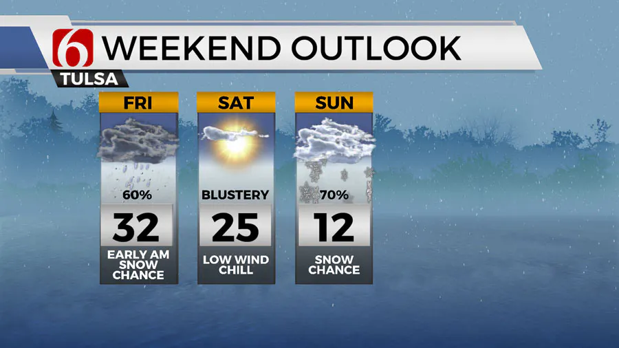
The upper levels of the atmosphere will be primed to bring at least one, possibly two short waves across the central and southern plains Sunday into Monday. As the arctic air remains in place, wintry precipitation will become more likely Sunday. The depth of the air mass will be sufficient to produce snow. Higher snow ratios are expected with the arctic airmass bringing some moderate to possibly significant accumulations of dry snow to the region. The combination of strong northeast winds will promote blowing snow. The exact timing and amounts will continue to be refined. The current data supports increasing probability by Sunday midday into the afternoon and ending by evening with the first disturbance. A small wave may near the area early Monday morning and could produce another smaller amount of snowfall. The main and more significant wave will arrive on Sunday.
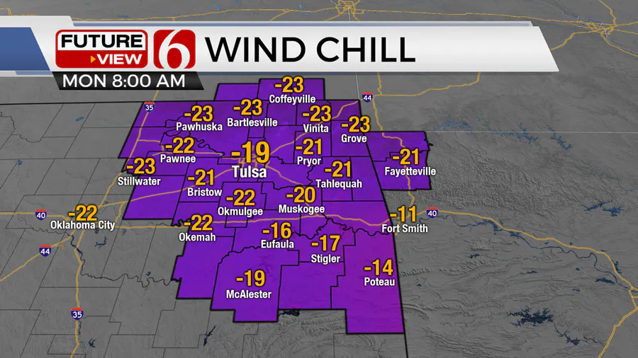
Monday through Wednesday morning will feature some of the coldest air of the last two seasons with morning lows near or slightly below zero and afternoon highs Monday in the teens and Tuesday into the 20s. Wind chill values Monday morning will be between -10 and -20.
CLICK HERE for Alan Crone’s weather podcast.
How to prepare my home for a freeze?
The City of Tulsa says it’s important to protect your pipes from the cold.
Officials recommend protecting outside pipes by disconnecting garden hoses from your house and installing covers on outside faucets.
Also, if a sink is along an outside wall of your home, allow a trickle of water to run and open the cabinet doors to allow warm air to circulate.
The National Weather Service says when temperatures drop to 28°F or lower for a couple of hours you should bring pets indoors, protect sensitive vegetation, protect outdoor pipes and let indoor faucets drip and to turn off automatic sprinklers.
Space Heater Safety Tips (via CBS News)
- If you’re using a space heater, make sure it’s not too close to things that can burn like upholstered furniture, clothing, a mattress, or bedding.
- Never plug a space heater into an extension cord, always plug it directly into a wall outlet.
- Remember to turn it off before leaving the room or going to bed. Keep it out of the reach of children and pets. Look for signs of malfunctions, especially on older models.
- Make sure it has an automatic shutoff function.
- Make sure you have working smoke detectors with fresh batteries. Change the battery twice a year.
On average, fires caused by portable heaters cause 65 deaths and 150 injuries a year, according to the US Fire Administration.
Follow the News On 6 Meteorologists on Facebook!
————

Sarah Wilson is your guide to the latest trends, viral sensations, and internet phenomena. With a finger on the pulse of digital culture, she explores what’s trending across social media and pop culture, keeping readers in the know about the latest online sensations.


