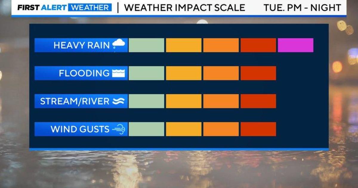
BALTIMORE — “ALERT DAY” is in effect today into tonight for risk of heavy rain, flash, stream, & river and coastal flooding and damaging winds.
The WJZ First Alert Weather Team has issued an “ALERT DAY” for heavy windswept rain and the potential of flooding, river & stream flooding, coastal flooding, and potential strong to damaging winds. Heavy rain will end late Tuesday night, but strong wind gusts will continue into Wednesday.
School early dismissal
Harford County and Anne Arundel County schools will be dismissing early on today because of a forecasted strong storm moving into the area.
There will be no after-school activities for those districts.
Harford County Public Schools will let out three hours early, while Anne Arundel County Public Schools will release two hours early.
Baltimore County Public Schools has canceled all after-school activities.
In Cecil County, secondary schools will close at 12 p.m. and elementary students at 1 p.m.
For a full list, visit our schools website.
[RELATED: Here’s how to stay safe when a storm knocks your power out]
What we can expect
Confidence continues to be high for a widespread, high-impact weather event today into tonight across the state of Maryland. This is the same storm system that will paralyze parts of the Midwest and Plains with blizzard conditions, deliver severe to potentially destructive thunderstorms and tornadoes to the south and southeast, and bring flooding downpours and damaging winds to much of the East Coast.
[MORE: Flooding concerns come with Tuesday’s potentially powerful storm]
WHO: Entire Maryland viewing area
WHAT: Extremely strong area of low pressure moving across our part of the country today into early Wednesday. This low pressure is exceptionally and unusually strong, and is in a different league from storms that we normally experience.
- HEAVY RAIN: Potential of 2″ to 3″ with locally 4″, much of that falling in a 6 hour window in the early evening. This will cause dangerous driving conditions Tuesday evening into early Tuesday night. The downpours Tuesday evening will be blinding and flash flooding could begin quickly.
FRESH FUTURE RADAR & WINDS TUE & TUE NIGHT: Here’s a future radar simulation of how tomorrow’s rain & wind plays out. During this time range & in these type of storms, our HRRR (High Resolution Rapid Refresh) model tends to be superior. Rain all day, but disruptive PM/eve. @WJZ pic.twitter.com/zus8SXyb5X
— Steven Sosna (@SteveSosnaWX) January 9, 2024
- WIDESPREAD FLOODING: Since the drought is over, the ground has been saturated. 6 hour flash flood guidance indicates that just 0.75″ of rain in less than 6 hours will cause flash flooding in the urban corridor between DC – Baltimore. This means many urban areas will experience flooding Tuesday evening and night. Road closures and disruptions are likely if these amounts are verified.
MODERATE RISK FOR FLOODING. But what does that mean? Our area has been placed in a “moderate risk” (level 3 out of 4) for flooding & flash flooding Tuesday into Tuesday night. We have a 40 to 70% chance of flash flooding within 25 miles of any point within orange shading. @wjz pic.twitter.com/gUcw9M0P2g
— Steven Sosna (@SteveSosnaWX) January 9, 2024
- RIVER & STREAM FLOODING: We did not experience much stream/river flooding at all in 2023. Different story with this storm. Streams and rivers are at capacity from recent heavy rains events and upstream snow/ice melt to our north will contribute to potential flooding. I’m expecting numerous flood warnings (if rainfall amounts are verified) late Tuesday night through Wednesday. This may cause significant road closures near vulnerable streams and rivers overnight Tuesday into Wednesday morning for the commute. Our weather team can update you on which streams/rivers as we get closer: https://www.weather.gov/marfc/
- WIDESPREAD COASTAL FLOODING: Coastal flood warnings are in effect for MODERATE to coastal flooding for all of our counties that border Chesapeake Bay Tuesday evening through Wednesday morning. Widespread flooding at high tide is likely. This will be a higher impact even than our previous coastal flood days over the past month.
UPDATED COASTAL FLOODING FORECASTS: SIGNIFICANT coastal flooding in many areas between 9 PM Tuesday (parts of eastern shore) to early Wednesday AM (2 AM – 8 AM) elsewhere. Salt water levels rise 1-3 FT above dry ground. Specific locations & impacts below. @wjz @DerekBeasleyWX pic.twitter.com/M6jArNgrxq
— Steven Sosna (@SteveSosnaWX) January 9, 2024
- STRONG WIND GUSTS, POTENTIALLY DAMAGING GUSTS: Wind will be fierce with this storm. Right now confidence of 50 MPH gusts is high. Models are suggesting gusts as high as 45 to 65 MPH. While those higher end gusts shouldn’t be widespread, there could be a few reports of them. The best chance of 60 to 70 MPH gusts would be eastern shore communities, esp. closer to the beaches. This is where HIGH WIND WATCHES have been issued. An extremely powerful jet stream right over head combined with heavy rain bands will transport some of these strong to damaging winds to the ground. This looks like dinner hour Tuesday into the early overnight hours (subject to change as we approach storm). This would cause potential tree damage, power outages. In & around Baltimore, 50 to 55 MPH gusts seem possible. Out across the higher elevations to our west, a few hours of 60 MPH gusts seem possible Tuesday evening.
FUTURE GUSTS: Damaging winds are LIKELY in scattered to many locations Tue. evening & night. The reason why these gusts can cause so much damage is saturated soil. Threshold of knocking trees down is much lower w/ gusts 40 MPH able to cause damage. Some gusts may reach 60 MPH. pic.twitter.com/bauufBb0I1
— Steven Sosna (@SteveSosnaWX) January 9, 2024
- Tuesday Morning: Showers and rain develop across the area after 5 to 7 AM. .
- Tuesday Afternoon: Steady to heavy rain, turning windy. Some pockets of flooding possible.
- Tuesday Evening & Night: High impact conditions with tough to dangerous travel
- Wednesday: Residual early AM shower. River & stream flooding continues in some places, which may prompt road closures. Trees may also be down blocking streets & highways during the morning commute.. Winds briefly gust to 40 to 45 MPH late morning through mid-afternoon.
OTHER IMPACTS: This will cause widespread travel delays, disruptions, cancellations starting Monday and lasting through early Wednesday across the central and eastern United States. Both air travel and road travel will be highly impacted. People should expect numerous flight delays/cancellations if this storm meets its potential.
Quiet weather returns later Wednesday into Thursday.
Yet another significant storm is possible with heavy rain, strong winds, and even a few isolated severe thunderstorms are possible next Friday into Saturday. Stay turned as the WJZ First Alert Weather Team will provide updates on both storms throughout the week.
Please make sure to have your phones and tablets charged Tuesday morning, so that if you lose power, you can stream WJZ and CBS News Baltimore by going to www.wjz.com or downloading the WJZ app. We will provide non-stop storm updates Tuesday through Wednesday until all storm impacts come to an end.

Amanda Smith is a dedicated U.S. correspondent with a passion for uncovering the stories that shape the nation. With a background in political science, she provides in-depth analysis and insightful commentary on domestic affairs, ensuring readers are well-informed about the latest developments across the United States.