BOSTON – We’ve got an April mess unfolding across southern New England with a variety of precipitation types and impacts from town to town.
CBS Boston
Winter Storm Warning
The National Weather Service has issued a winter storm warning for northern Worcester County and extreme northwestern Middlesex County. A winter weather advisory has been issued in parts of western Essex and Middlesex counties as well as southern Worcester County.
This area, around the edges of 495, is the toughest area to pin down in this storm. We do expect some minor snow and sleet accumulation in these towns and therefore, the potential for some slippery travel.
CBS Boston
Storm timeline
Through Midnight: Mainly rain across eastern MA, heavy at times with some localized flooding. There will be some sleet pellets and snowflakes mixing in at times.
North and west of 495 there will be much more sleet involved. Thankfully, temperatures will remain above freezing so there really isn’t a concern for icy roadways.
CBS Boston
After midnight, some colder air will arrive. This will change the sleet over to snow north and west of 495 and eventually, as far south as the Mass Pike and the Worcester/Boston area.
Many folks across northern MA and southern New Hampshire will wake up to a fresh coating to a few inches of wet snow.
If you need to travel or commute Thursday morning from the north, plan on needing some extra time.
CBS Boston
During the day on Thursday, there will be a dry slot developing across southeastern MA. Most of the precipitation will be located north of the Mass Pike and in the form of snow.
We don’t expect a lot of additional accumulation during the daylight hours on Thursday, perhaps just underneath some of the heavier bursts.
The snow will taper in most areas during the afternoon. By evening, we will be left with just some lighter flurries over northern Essex County and southern New Hampshire.
CBS Boston
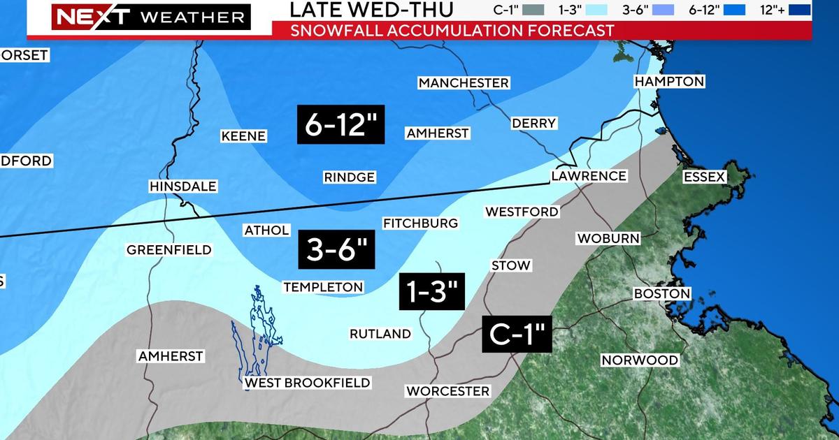
How much snow will Massachusetts and New Hampshire get?
There will be stark differences in snow accumulation over very short distances. Even within one town that has variable elevation (hills and valleys) there could be several inches of variability in accumulation.
We do not expect any accumulation in the Boston area or inside the 128 belt. (Although there may be some wet snow in the air from time to time)
Pretty much all rain over southeastern MA and all areas south of the Pike as well.
CBS Boston
North and west of 128, through about 495, there should be some sticking to surfaces, perhaps enough for scattered coating up to an inch.
North and west of 495, including northern Middlesex and Essex counties, there may be as much as 1-3″, again more so on grass than roads.
In the higher elevated areas of northern Worcester County and far northwestern Middlesex County, we are forecasting 3-6″ of pasty, wet snow.
Some of the higher peaks extending into southwest New Hampshire could receive as much as 6-12″.
Given the heaviness of the snow, any accumulation on tree limbs will be dangerous. Combine this with the strong wind forecast, and we could very well be looking at numerous power outages in the higher snow areas.
High Wind Warning
The winds will be strongest overnight into Thursday morning.
We expect frequent easterly gusts between 30-50mph across the entire region. Along the immediate coastline, the National Weather Service has issued a high wind warning for the potential of gusts as high as 60mph.
CBS Boston
As the storm’s center crosses over southern MA during the day Thursday, the winds will decrease significantly over southeastern MA but ramp up one final time over northeast MA and the New Hampshire and Maine coastlines.
Coastal Flood Warning
We are particularly concerned about the area from Cape Ann to Salisbury to Hampton, NH, locations that have been battered time and time again the last several months.
CBS Boston
In these areas, there may be minor to moderate flooding along with another round of beach erosion.
There is now a Coastal Flood Warning in place for the entire east coastal region between 6-10am Thursday.
CBS Boston
The major impacts from the storm will wind down Thursday evening but the storm itself will be very slow to pull away from the region.
Lots of clouds will remain on Friday, Saturday and even into early Sunday. There will also be some pop-up rain and snow showers during this time.

Amanda Smith is a dedicated U.S. correspondent with a passion for uncovering the stories that shape the nation. With a background in political science, she provides in-depth analysis and insightful commentary on domestic affairs, ensuring readers are well-informed about the latest developments across the United States.