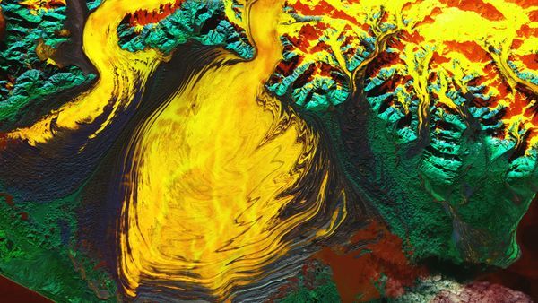
NASA has released a trippy, technicolor satellite photo of Alaska’s Malaspina Glacier, which makes the massive ice mass look like a fiery, rippling blob of paint. The new image highlights recent discoveries at the glacier, including a “hidden lagoon.”
The glacier, in Wrangell-St. Elias National Park on the state’s southeastern coast, covers around 1,680 square miles (4,350 square kilometers), making it North America’s largest glacier and the world’s largest piedmont glacier — a type of lobed glacier that spills out from mountains onto flattened ground.
Malaspina Glacier is also known as Sít’ Tlein, which means “big glacier” in the Tlingit language spoken by the Indigenous people in the area.
The image was captured on Oct. 27 by the Landsat 9 satellite, which is co-owned by NASA and the U.S. Geological Survey. It was released by NASA’s Earth Observatory on Nov. 25.
The picture is a false-color image created using infrared radiation. The yellow and orange colors represent ice; the red hues show water; and the blue and green colors show where land and vegetation occur, respectively. The ripples, or folds, in the ice are moraines — bands of soil, rock and other debris that are scraped up as the glacier slowly lurches forward.
Related: NASA Satellites Show How Our Icy World Is Melting
The Seward Glacier, which feeds into the Malaspina Glacier from the Saint Elias Mountains, and the Agassiz Glacier, which is fed by the same mountain range, are also visible in the image.
In February, a study published in the Journal of Geophysical Research: Earth Surface revealed that the volume of the Malaspina Glacier’s ice had previously been overestimated by around 30% — but if the entire ice mass were to melt away, it could raise the global average sea level by 0.06 inch (1.4 millimeters), the studys showed.
The study also revealed that the dark-red patch of water, located between the ice and an outstretched piece of land at the end of the glacier, is a saltwater lagoon that was hiding in plain sight. The lagoon is warmer than scientists previously suspected because of its high salt content, which could accelerate the ice melt rate.
The researchers also found that there are subglacial channels of water that run through the bedrock beneath the glacier. These channels extend up to 22 miles (35 kilometers) under the ice and could further accelerate the glacier’s retreat.

Dr. Sarah Adams is a scientist and science communicator who makes complex topics accessible to all. Her articles explore breakthroughs in various scientific disciplines, from space exploration to cutting-edge research.