In 2020, large swaths of the Pantanal wetlands in South America, one of the most biologically rich places on Earth, suffered unprecedented damage from wildfires, the worst of which burned unceasingly for a record two months.
The fires led to the hospitalization of many residents, killed an estimated 17 million animals and charred millions of acres of the Pantanal — the largest tropical freshwater wetland in the world — including Indigenous lands.
Now, new work mapping the extent of the burned area shows that the fires destroyed a much bigger area than initially thought. Using models based on images from Europe’s two Copernicus Sentinel-2 Earth-observing satellites, researchers now report that the blazes burned about 11.1 million acres (4.5 million hectares) of the Pantanal.
Related: Wildfire smoke is warming the planet more than previously thought, scientists say
The latest models have higher accuracy compared to previous models based on satellite data, which had a wide range — between 3.5 million acres to 8.9 million acres (1.4 to 3.6 million hectares). The new findings emphasize the importance of more accurate methods to measure impacts of wildfires in regions, like the Pantanal, that are especially sensitive to climate change, researchers say.
“The 2020 Pantanal fire crisis was caused by an extreme drought. Severe drought will tend to be increasingly frequent there and in other parts of Brazil,” study co-author Guilherme Mataveli, who is a researcher at the National Space Research Institute (INPE) in Brazil, said in a statement. “Knowing more about the impact of these extreme weather events on the biome and its biodiversity will be more and more important to decisions regarding fire management and fire mitigation programs.”
Mataveli and his team used images of the Pantanal region clicked by the MultiSpectral Instrument (MSI) sensor onboard the Sentinel-2 satellites from July to December 2020. The Pantanal experiences its dry season during this time each year, while it is a flooded wetland for the remainder of the year. A prolonged drought since 2019 had dried the region more than normal, leading to the fires burning 200% more area than average, with 35% of the biome scorched for the first time on record, according to the new study.
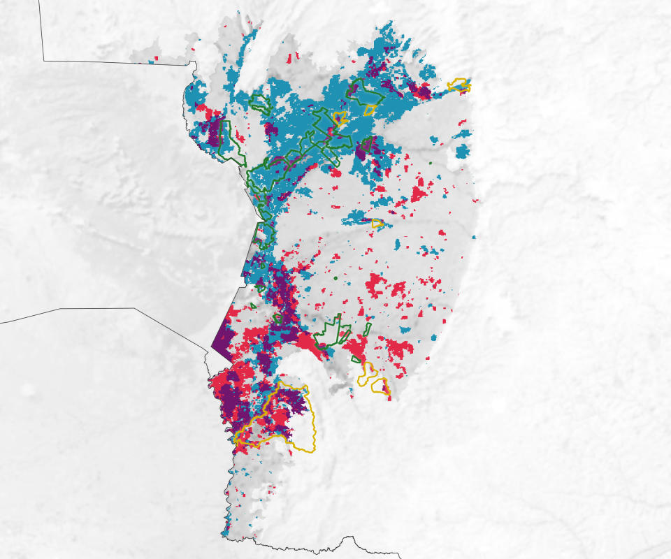
The Sentinel-2 satellites mapped the burned regions once every five days, which is more frequent than the once-in-10-days mapping done by NASA’s Landsat satellite, one of the data sources for past models. Models using Landsat data estimated that somewhere between 3.5 million acres and 5.7 million acres (1.4 to 2.3 million hectares) were burned in 2020, while those using data from NASA’s Terra and Aqua Earth-observing satellites estimated the charred area to span 8.9 million acres (3.6 million hectares).
“The results of the study don’t show one model or product to be better than another,” study co-author Andeise Dutra, a doctoral candidate at INPE, said in the same statement. “Every method has its own strengths and limitations. Estimates tend to vary significantly as a result.”
RELATED STORIES:
— Satellite imagery captures wildfires breaking across Greece (photo)
— Satellites watch wildfires rage across Canadian northwest (photos)
— Climate change may be changing the color of Earth’s oceans
That being said, such high-resolution imagery, combined with revisits to the same region every five days by the Sentinel-2 satellites, could allow researchers to build better models of wildfire impacts. And better models would help generate more precise estimates of trace gases and aerosols that make up wildfire smoke, researchers say.
The new work estimates that at least 2.2 million more acres (890,000 hectares) burned in Brazil’s Pantanal than previously thought, so the amount of greenhouse gases released into Earth’s atmosphere is also expected to be higher than currently measured.
The new research was described in a paper published July 2023 in the journal Fire.

Dr. Sarah Adams is a scientist and science communicator who makes complex topics accessible to all. Her articles explore breakthroughs in various scientific disciplines, from space exploration to cutting-edge research.