Severe Weather Team 2 is tracking another round of storms over north Georgia Thursday morning with the risk for embedded strong to severe storms.
This comes after the first round had a history of producing flash flooding, damaging wind gusts and hail Wednesday night and during the overnight hours.
Severe Weather Team 2 Chief Meteorologist Brad Nitz tracked multiple tornado warnings and severe thunderstorm warnings throughout the night. A tornado watch is expired at 4 a.m. in north Georgia.
Severe Weather Team 2 Meteorologist Brian Monahan says another round of strong and severe storms will move into north Georgia and metro Atlanta area on Thursday.
Damaging wind gusts and hail are the main impacts. A brief spin-up tornado remains possible.
Severe Weather Team 2 is LIVE tracking the storms, on Channel 2 Action News This Morning.
LIVE UPDATES:
5:11 a.m.
A Severe Thunderstorm Warning has been issued for Clarke and Oglethorpe counties until 6:00 a.m.
5:00 a.m.
2,184 Georgia Power customers in Gilmer county are without power after storms moved through.
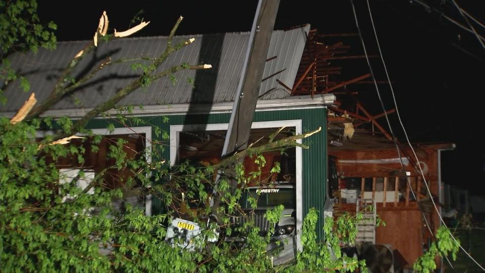
Channel 2′s Daryn Moore spotted damage at this home off Ellington Road in Ellijay.
In Hall County, about 2,760 Georgia Power customers are without power.
For Georgia EMC, it is reporting 12,250 customers in north Georgia, 3,564 customers in northeast Georgia and 2,235 customers without power.
4:00 a.m.
A tornado watch for counties in the Channel 2 Action News viewing area has been allowed to expire.
3:55 a.m.
A severe thunderstorm warning is in effect for Madison and Oglethorpe counties until 4:30 a.m.
3:19 a.m.
A Severe Thunderstorm Warning is effect for Barrow, Clarke, Jackson and Oconee counties until 4:00 a.m.
3:01 a.m.
A Severe Thunderstorm Warning is in effect for Barrow, Forsyth, Hall and Jackson counties until 3:45 a.m.
2:55 a.m.
New severe thunderstormw arning just issued for parts of Forsyth, Hall, Jackson, and Barrow Counties. 60 mph wind gusts aong with hail possible with this storm. @wsbtv pic.twitter.com/X1YDmyAbZY
— Brian Monahan, WSB (@BMonahanWSB) May 9, 2024
2:42 a.m.
A Flash Flood Warning has been issued for Dawson, Gilmer, Gordon, Lumpkin and Pickens counties until 8:45 a.m. Thursday.
Flash flooding is a big concern this morning over the north Georgia mountains where as much as 3-5″+ of rain has fallen in training thunderstorms. @wsbtv pic.twitter.com/VzaMNKPdIO
— Brian Monahan, WSB (@BMonahanWSB) May 9, 2024
2:17 a.m.
Still tracking the potential for severe thunderstorms over the mountains, though intensity has diminished some for now.
Stay weather aware. Another round coming later this morning! @wsbtv pic.twitter.com/tFl3HAfhMw
— Brian Monahan, WSB (@BMonahanWSB) May 9, 2024
2:11 a.m.
A Severe Thunderstorm Warning is in effect for Chattooga, Floyd, and Gordon counties until 3:00 a.m.
1:03 a.m.
12:33 a.m.
A Tornado Warning has expired for Clay County, North Carolina in the Channel 2 Action News viewing area.
12:28 A.M.
A Tornado Warning has been issued for Chattooga and Walker counties until 1:15 a.m.
12:00 a.m.
A tornado warning extended for Clay County, North Carolina in the Channel 2 Action News viewing area until 12:30 a.m.

Amanda Smith is a dedicated U.S. correspondent with a passion for uncovering the stories that shape the nation. With a background in political science, she provides in-depth analysis and insightful commentary on domestic affairs, ensuring readers are well-informed about the latest developments across the United States.