For most of Wednesday, travel adjustments meant closed roads for Lyon County drivers. One adjustment late Wednesday is easing travel somewhat.
The Kansas Department of Transportation has opened Kansas Highway 99 north of Emporia after it was closed virtually all day due to floodwaters. However, other roads remain closed and may be barricaded for several days:
*Road 140 700 block
*Road 150 from D to E; J to Kansas Highway 99
*Road 160 from G to H; from N to P
*Road 167 from R to S
*Road 170 and G (Merrick Tower)
*Road 170 from F to G; from S to U
*Road 180 from Burlingame to N-5; from Y to Z
*Road 190 from K to Kansas Highway 99; from L-5 to N
*Road 195 from Kansas Highway 99 to L-5
*Road 200 from Burlingame to R
*Road 210 from Burlingame to R-7
*Road 215 from F-5 to H-5
*Road 220 from N to S
*Road 225 from F-5 to Emporia city limits
*Road G south of 50; from 150 to 175
*Road G-5 from 155 to 160
*Road H from 155-170
*Road J from 190 to 215
*Road K from 190 to 210; from 220 to 230
*Road L from 110 to 130
*Road M from 190 to 200
*Road M-7 from 160 to 165
*Road N from 160 to 170; 210 to 220
*Road P from Burlingame to 240
*Road R from 160 to 167
*Road S from 190 to 200
*Road W from Kansas Highway 170 to Road 270
*Road X from 255 to 270
*Road Y from 255 to 280
*Road Z from Kansas Highway 170 to Road 270
Meanwhile, flood warnings have been extended for portions of the KVOE listening area.
The flood warning affecting much of Lyon County, including Emporia, Americus, Neosho Rapids, Olpe and Reading, now ends at 9:15 pm Wednesday. Also affected are the Kansas Turnpike between mileposts 117-140, or 10 miles southwest of the Emporia gate to seven miles southwest of the Admire exit, and Interstate 35 between mile markers 128-143, or west Emporia to the Lyon-Coffey county line.
Up to 10 inches of rain has fallen in the alert area. The National Weather Service says another inch is still possible.
The flood warning for most of Osage County, including Lyndon, Melvern, Melvern Lake and Osage City, now ends at 9:30 pm Wednesday. This also includes Interstate 35 between mile markers 159-190.
The National Weather Service says up to 9 inches of rain have fallen in this area and another inch is possible.
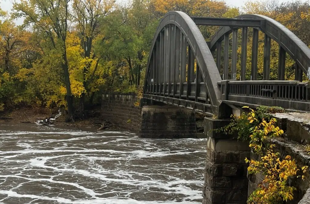
Salt Creek near Lyndon remains in a flood warning until Thursday morning, but the river continues to fall after cresting at just over 12 feet Wednesday morning. The river will likely go below flood stage Wednesday evening unless additional rainfall causes another rise.
The Neosho River at Neosho Rapids is not in flood stage or a flood warning currently, but it is approaching flood stage of 22 feet. The river is at 17.7 feet and could go above flood stage Thursday afternoon. The current forecast has the river cresting at 22.5 feet. The river had been running at under a foot before this round of rain.
Chase County’s flood watch continues until 1 am Thursday.
Wet conditions led to several reported injury crashes in the KVOE listening area Wednesday.
Two wrecks were reported, one on the Kansas Turnpike five miles northeast of the Admire exit shortly before 1 pm and another on the Turnpike a mile north of the Matfield Green service exit about 15 minutes later. Four people were observed on site. All four declined hospital treatment afterward.
Stay with KVOE, KVOE.com and KVOE social media for updates.
9:15 am to 3:30 pm: K-99 closed north of Emporia; more flood alerts announced as NWS Halls Summit transmitter goes back offline
Extremely heavy rainfall is affecting traffic for a large portion of Lyon County.
Road closures as announced by the Lyon County Highway Department:
*Kansas Highway 99 from Emporia north city limits to Road 210
*Road 140 700 block
*Road 150 from D to E; J to Kansas Highway 99
*Road 160 from G to H; from N to P
*Road 170 and G (Merrick Tower)
*Road 170 from F to G; from S to U
*Road 180 from Burlingame to N-5
*Road 190 from K to Kansas Highway 99; from L-5 to N
*Road 195 from Kansas Highway 99 to L-5
*Road 200 from Burlingame to R
*Road 210 from Burlingame to R-7
*Road 215 from F-5 to H-5
*Road 220 from N to S
*Road 225 from F-5 to Emporia city limits
*Road G south of 50; from 150 to 175
*Road G-5 from 155 to 160
*Road H from 155-170
*Road J from 190 to 215
*Road K from 190 to 210; from 220 to 230
*Road L from 110 to 130
*Road M from 190 to 200
*Road M-7 from 160 to 165
*Road N from 160 to 170; 210 to 220
*Road P from Burlingame to 240
*Road S from 190 to 200
*Road W from Kansas Highway 170 to Road 270
*Road X from 255 to 270
*Road Y from 255 to 280
*Road Z from Kansas Highway 170 to Road 270
Meanwhile, central Lyon County, including Emporia, Americus, Neosho Rapids, Olpe and Reading, is in a flood warning until 3:15 pm after up to 9.5 inches of rain fell overnight and another inch of rain is listed as possible. This also includes the Kansas Turnpike between mile markers 117-140, or 10 miles southwest of the Emporia tollgate to seven miles southwest of the Admire exit. It also includes Interstate 35 from west Emporia to the Lyon-Coffey county line, or mile markers 128-143.
A flood warning affects the southern two-thirds of Osage County until 3:30 pm, including Lyndon, Melvern, Melvern Lake and Osage City. It also includes mile markers 1548-190 on Interstate 35. Numerous road closures have been reported by law enforcement.
Salt Creek near Lyndon, meanwhile, is in a flood warning until Thursday morning.
*Minor flooding is underway with the river at 11 feet, one foot above flood stage. The river has apparently crested at just over 12 feet, better than two feet below its projected crest. The river had been at less than a foot before the rain developed late Tuesday.
A flood watch affects Chase County through Wednesday evening with the chance of more flooding rainfall through the day.
This comes as the Weather Service transmitter at Halls Summit is offline again. The transmitter has had intermittent issues with its signal all year. The transmitter serves Lyon, Chase, Coffey, Greenwood and Osage counties. Other transmitters are available:
*WXK-91 at Topeka, broadcasting on Channel 4 or 162.475 MHz
*WXK-95 at Chanute, broadcasting on Channel 1 or 162.400 MHz
*WZ-2512 at Parker, broadcasting on Channel 6 or 162.525 MHz
*KID-77 at Kansas City, broadcasting on Channel 7 or 162.550 MHz
7:30 am-9:15 am Wednesday: Water rescue ends well at Road 190 and K-99; first round of Lyon County road closures announced
The heavy rainfall from Tuesday night through the pre-dawn hours Wednesday has caused several significant travel issues.
There have been several incidents where law enforcement and emergency personnel were called out to a vehicle stalled in running water, including a water rescue at K-99 and Road 190. Most details are pending, but Emporia Fire says they took the driver and only occupant to safety.
There were also stuck vehicles in the 2600 block of Road W shortly before 5 am and at Seventh and West shortly before 6 am.
Drivers are urged to avoid using Kansas Highway 99 north of Emporia, especially from the 1900 block ot the 2400 block of the highway. Emporia State Police and Safety says East 18th is closed around the Prophet Aquatic Research and Outreach Center. Other Lyon County road/intersection closures:
*Road 150 from J to Kansas Highway 99
*Road 170 and G (Merrick Tower)
*Road 190 and M
*Road 190 from L-5 to N
*Road G south of 50
*Road M from 190 to 200
*Road N from 210 to 220
*Road W from Kansas Highway 170 to Road 270
Stay with KVOE and KVOE.com for updates.
5:30-7:30 am Wednesday
Extremely heavy rainfall has led to flood alerts for parts of the KVOE listening area.
Much of central Lyon County, including Americus, is in a flash flood warning until 9:15 am after anywhere between 3-7 inches of rain fell overnight. This also includes the Kansas Turnpike between mile markers 129-141, or two miles northeast of the Emporia gate to six miles southwest of the Admire exit. Another two inches are possible in some alerted areas.
There is an additional flash flood warning officially for south Lyon County, including Emporia, Neosho Rapids, Olpe and Reading, until 9:45 am. This also involves the Kansas Turnpike between mile markers 117-130, or 10 miles southwest of the Emporia gate to three miles northeast of the gate. It also includes Interstate 35 between mile markers 128-143, or west Emporia to the Lyon-Coffey county line. Up to 9 inches of rain has fallen in this alert box, according to the National Weather Service.
A flash flood warning affects northwest Coffey County and virtually all of Osage County until 10:30 am. This also includes Interstate 35 between mile markers 144-153 and also 169-181. Between 3-9 inches of rain has already fallen, according to Weather Service radar estimates.
An urban and small stream flood advisory affects most of Osage County, including Lyndon, Melvern and Melvern Lake, until 7 am. Up to 4 inches of rain have fallen there with another inch possible before the rain stops.
A flood watch affects Chase County through Wednesday evening with the chance of more flooding rainfall through the day.
TV-13 meteorologist Doug Meyers says a frontal boundary is wringing out the atmosphere at this time.
There are some impressive rain totals so far:
*KVOE studios: 6.9 inches
*Emporia Municipal Airport: 3.8 inches
*3 miles east of Emporia Municipal Airport: 5.4 inches
*West edge of Emporia Community Club: 8 inches
*3 miles west of Emporia Golf Course: 3.7 inches
*Coronado Avenue: 6.2 inches
*Deerbrook Addition: 4.8 inches
*Seventh and Market: 6.2 inches
*Ninth and Arundel: 4.5 inches
*20th and Graphic Arts: 6.5 inches
*South and Sylvan: 6 inches
*10th and Weaver: 7.2 inches
*100 block Exchange: Over 7 inches (gauge full)
*700 block South Exchange: 5 inches
*1100 block Constitution: 5.5 inches
*1300 block Prairie Park Lane: 9.03 inches
*1900 block Burlingame: 9.4 inches
*5 miles south-southwest of Emporia: 4.39 inches
*Allen: 0.50 inches
*Americus Fifth and Orange: 4 inches
*Americus 1200 block Main: 3.8 inches
*7 miles east of Americus: 8.12 inches
*2 miles south of BETO Junction: 3.09 inches
*6 miles north of Gridley: 2.3 inches
*Between Hartford and Gridley: 2 inches
*Between Hartford and Olpe: 2.36 inches
*Lamont: 2.3 inches
*Lebo: 4.5 inches
*2 miles north of Lebo: 5 inches
*1 mile north of Lyndon:8.10 inches
*5 miles east of Madison: 2.5 inches
*Melvern: 5.88 inches
*4 miles southwest of Miller: 5.14 inches
*Neosho Rapids: 3.5 inches
*Olpe: 3.85 inches
*Olpe Blacksmith Shop: 3.75 inches
*Olpe Lake: 3.8 inches
*Southwest of Olpe: 4 inches
*1 mile west of Olpe Ag Choice: 6.1 inches
*1 mile south-southeast of Osage City: 7.59 inches
*Reading: 5 inches
*Road 140 and D: 6 inches
*Road 170 and R-1: 4.8 inches
*Road 180 between E and E05: 8.28 inches
*Roads 270 and U: 8.62 inches
*700 block Road 200: 5.82 inches
*1 mile north of Saffordville: 4.1 inches
*Thorndale: 4 inches
*Toledo: 4.63 inches
Drivers are urged to avoid using Kansas Highway 99 north of Emporia, especially from the 1900 block of the 2400 block of the highway. Emporia State Police and Safety says East 18th is closed around the Prophet Aquatic Research and Outreach Center. Lyon County road closures:
*1900 block Burlingame
The National Weather Service reminds you to turn around so you don’t drown when encountering flooded roads. Most flood deaths occur in vehicles. Also, be especially cautious at night when it is harder to recognize the
dangers of flooding.
There have been at least two incidents where law enforcement and emergency personnel were called out to a vehicle stalled in running water. Deputies, as well as emergency responders from Emporia, Miller and Reading, were dispatched to the 2600 block of Road W shortly before 5 am. The person got to safety. Also, Emporia Police were called to help a driver at Seventh and West shortly before 6 am.
More rain is likely through Wednesday night, and there is still a 50-50 chance of rainfall Thursday morning and early afternoon.
Stay with KVOE, KVOE.com and KVOE social media for updates. If you have rain totals, message the Bluestem Farm and Ranch text line at 620-342-5863.

Sarah Wilson is your guide to the latest trends, viral sensations, and internet phenomena. With a finger on the pulse of digital culture, she explores what’s trending across social media and pop culture, keeping readers in the know about the latest online sensations.