- A strong El Niño will be in place for Christmas this year.
- El Niño can mean warmer-than-average temperatures in much of the Lower 48, which can impact snow chances.
- However, not all areas have a lower chance of a white Christmas during strong El Niños.
El Niño can produce more or less snow than an average winter, depending on a number of factors. So what might this mean for your chances of a white Christmas?
A strong El Niño is in place this year and there have been eight previous strong El Niños since 1950. Not all strong El Niños are the same as the most recent ones demonstrate, so we dove into the data of those eight Christmases for clues on what we might expect this year.
What counts as a “white Christmas”? There has to be at least one inch of snow on the ground on Christmas morning. It doesn’t have to snow on the actual holiday. A trace of snow also doesn’t count.
The map below shows the historical chance of a white Christmas based on data from 1991-2020. Odds of a white Christmas are greater than 50% for much of the Mountain West and far Northernier.
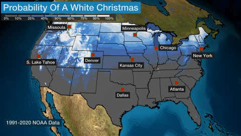
Historical chance of a white Christmas in any given year, based on 1991-2020 data from NOAA.
There is an overall temperature and precipitation pattern that emerges for December. The eight years that had a strong El Niño in place for December are 1957, 1965, 1972, 1982, 1991, 1997, 2009 and 2015. When those years are combined and compared to the current 30-year averages (1991-2020), a distinct December temperature pattern emerges and is shown on the map below.
The temperature pattern for strong El Niño Decembers includes warmer-than-average conditions for the Northern Plains, Midwest and most of the South and Northeast. Much of the West experienced temperatures colder than average.
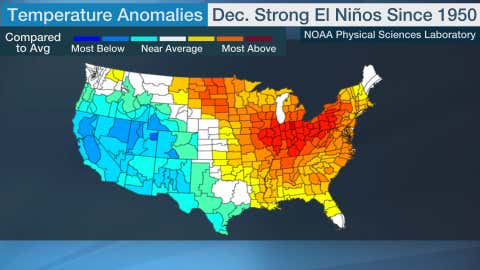
Temperatures compared to the 1991-2020 average for Decembers in 1957, 1965, 1972, 1982, 1991, 1997, 2009 and 2015.
(NOAA Physical Sciences Laboratory)
December precipitation in strong El Niño years also has some interesting features. Precipitation is notably above average for the majority of the South, as well as into the mid-Mississippi Valley and southern Great Lakes. There are also signals of more precipitation than average in parts of the Southwest and Northwest.
Interestingly, Northern California jumps out as seeing less precipitation than average for December. The overall theme of those eight years was close to average for the rest of the Lower 48.
(192-hours: Further beef up your forecast with our detailed, hour-by-hour breakdown for the next 8 days – only available on our Premium Pro experience.)
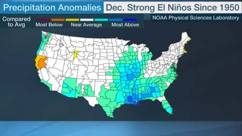
Precipitation compared to the 1991-2020 average for Decembers in 1957, 1965, 1972, 1982, 1991, 1997, 2009 and 2015.
(NOAA Physical Sciences Laboratory)
White Christmas chances are reduced in the Northeast in strong El Niño years. The big cities in the Northeast don’t often see snow on the ground Christmas morning and that is true in strong El Niño years, with most only experiencing a white Christmas in 2009.
Much of the interior Northeast and even northern New England, however, also measured less snow than average on Christmas in those eight strong El Niño years. The lack of snow in parts of the Northern Tier is due in part to warmer temperatures that can accompany El Niño there.
For example, Syracuse, New York, has a 58% chance of a white Christmas overall, but only reported an inch of snow in 1991 and two inches in 2009, which is just 25% of strong El Niño years. Pittsburgh has only seen a white Christmas once when a strong El Niño was in place, which is lower than its typical 32% chance.

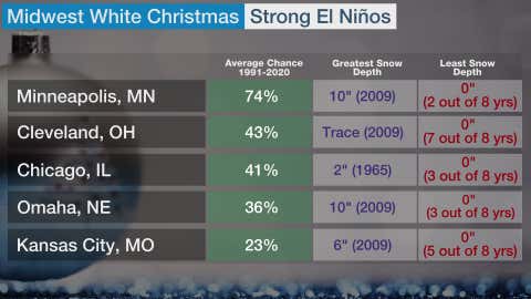
The average chance of a white Christmas is in the first column. The second column shows the highest snow depth on Christmas morning during a strong El Niño. The third column shows the least amount of snow on Christmas morning during a strong El Niño and how many of the eight years that snow depth occurred.
Portions of the Midwest saw a bare ground for all of the strong El Niño years. The lack of a white Christmas was striking for Cleveland and Detroit, where about 40% of Christmases have at least an inch of snow on the ground but no strong El Niño years reached white Christmas criteria. Indianapolis and St. Louis also did not get a white Christmas in any of those eight years.
Minneapolis reported a white Christmas in three out of eight years, which is notably lower than their overall chance of 74%. Des Moines, Iowa, however, saw a white Christmas six out of eight years, which is higher than their 43% chance over the 30-year average.
All eight years in Duluth, Minnesota, were classified as white Christmases, which is close to their average of 92%. Chicago had an inch or two on the ground four out of eight years, which is also not too far off from their average chance of 41%.
The average chance of a white Christmas is in the first column. The second column shows the highest snow depth on Christmas morning during a strong El Niño. The third column shows the least amount of snow on Christmas morning during a strong El Niño and how many of the eight years that snow depth occurred.
The West is the winner for white Christmases in strong El Niño years. Western locations that typically experience a white Christmas have a greater chance during a strong El Niño. This is due to the usually more active jet stream across the West in El Niño years.
Tahoe City, Flagstaff and Salt Lake City all have around a 20% higher chance of seeing a white Christmas in a strong El Niño year. However, the amount of snow on the ground can vary greatly, as shown below. Farther east, Billings, Montana has reported a white Christmas in four out of eight years which is slightly above its 30-year average of 42%.
As expected, Anchorage and Faribanks, Alaska, observed a white Christmas in all eight years with snow on the ground ranging from two inches to 23 inches in Anchorage and three to 39 inches in Fairbanks.
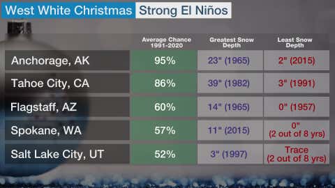
The average chance of a white Christmas is in the first column. The second column shows the highest snow depth on Christmas morning during a strong El Niño. The third column shows the least amount of snow on Christmas morning during a strong El Niño and how many of the eight years that snow depth occurred.
Linda Lam is a lead meteorologist at weather.com. Growing up in Massachusetts she developed a fascination for winter storms and hurricanes that led her to pursue a career in meteorology.
The Weather Company’s primary journalistic mission is to report on breaking weather news, the environment and the importance of science to our lives. This story does not necessarily represent the position of our parent company, IBM.

Amanda Smith is a dedicated U.S. correspondent with a passion for uncovering the stories that shape the nation. With a background in political science, she provides in-depth analysis and insightful commentary on domestic affairs, ensuring readers are well-informed about the latest developments across the United States.